
How many times have you, as a citizen, encountered problems on the street and wished you could do something about it? Or wanted to know when the civic work happening on your street is supposed to complete? Or felt curious about how your neighbourhood compares with others in terms of quality of life?
We believe that citizens would be able to engage much more closely with their Corporators, MLAs and local government officials if they had the right information about their neighbourhood.
Open Works is an initiative to open up the data on City budgets and operations at a hyper-local level with the aim of catalysing citizen participation in governance. This will happen through the creation of 'online' as well as 'offline' channels for citizens to demand rational allocation of funds and better service delivery for their neighbourhoods based on fully transparent governance.
The Spatial module presents an integrated view of a city's finances and operations in the form of geospatial data pertaining to -
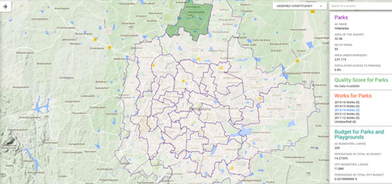
We believe that this will interest not only citizens but also elected representatives and City officials. The aim is to allow correlations and patterns to emerge through presentation of geocoded data points against the backdrop of a street map as well as aggregated metrics against Ward and Assembly Constituency boundaries.
The objective of Street Quality Score is
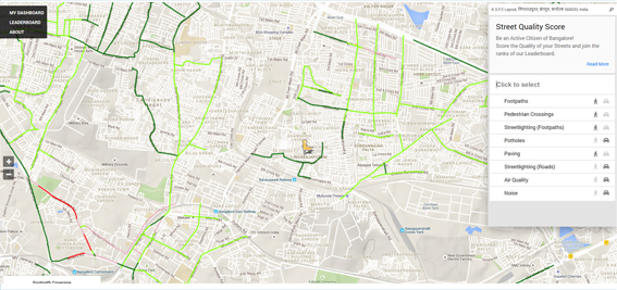
The survey involves on-ground, physical measurement of Quality of Life indicators as we consider these to be an objective basis for ward-level budgetary allocations.
For certain indicators we have also created a platform for crowd-sourcing surveys through citizen participation. This will allow active citizens to go out and measure the quality of their streets and feed us back actionable data that will help influence Ward budget allocations.
The Budget module analyzes the City budget in terms of allocation of funds across Wards and Assembly Constituencies (AC) as well as across service categories such as roads, drains, parks, water, sanitation etc. These are based on an analysis of the project descriptions appearing against each "Payment Code" in the City budget.
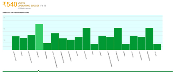
The budget section provides certain key insights into the City budget -